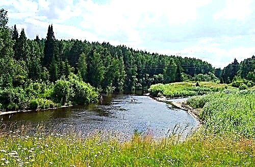
The Tomsk region is rich in water bodies. All of them belong to the basin of the Ob River - the largest waterway in the region. More than 1,500 rivers are over 10 km long. The total length of all rivers in the region is 95,000 km. A distinctive feature of the rivers of the Tomsk region is their flat nature. They are characterized by a winding channel, a calm current and a small slope.
There are recreation areas on the banks of large rivers, and many travelers are engaged in water tourism. There are both organized excursion routes and rafting routes for independent travelers. They pass through the territories of reserves and natural monuments. Medium and small rivers are not so popular due to their location. Most of them run through hard-to-reach taiga forests.
The longest rivers of the Tomsk region
List of the largest rivers flowing through the region.
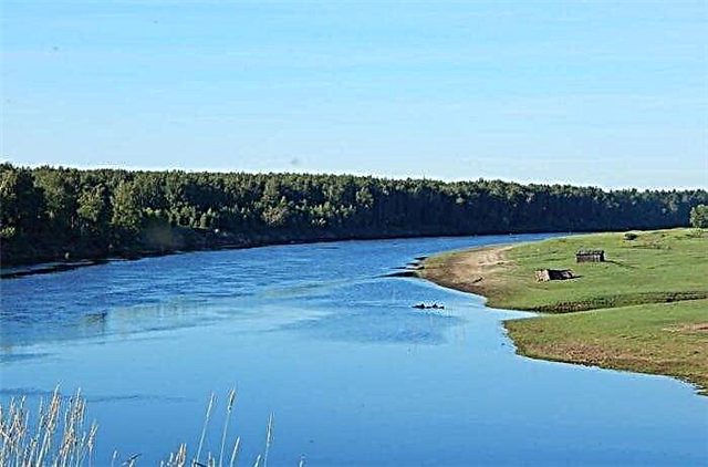
Ob
It flows through several regions and climatic zones. In the Tomsk region, the nature of the shores is represented by dense coniferous forests. Part of the forests is included in the protected area of the Tomsk reserve. Rare animals live here and there is a site of the Scythian period. The Ob flows through the Tomsk and Novosibirsk regions, the Altai Territory, the Khanty-Mansi and Yamalo-Nenets districts.
The length of the river is 3650 km, in the Tomsk region - 1080 km.

Chulym
The water level varies greatly throughout the year. In summer, its current forms dangerous rifts, this circumstance, as well as the strong tortuosity of the channel, attracts fans of extreme rafting to the river. At the same time, it is popular among tourists because of the beauty of the shores, and among fishermen because of the abundance of fish. Chulym flows through the Krasnoyarsk Territory, the Tomsk and Kemerovo Regions, the Republic of Khakassia.
The length of the river is 1799 km, in the Tomsk region - 725 km.

Ket
A flat river carrying water through coniferous forests. The Ket River has a very winding channel in the upper reaches. But after the Orlovka river flows into it, it breaks up into many channels with rifts. Not only locals come to Keti to go fishing, because it is home to valuable species of fish - nelma and sterlet. It flows in the Tomsk Region and the Krasnoyarsk Territory.
The length of the river is 1621 km, in the Tomsk region - 805 km.

Vasyugan
The river is navigable almost along its entire length. The upper reaches of the river are located in one of the largest swamps in the world - Vasyugan. There are many rubble in the riverbed. In the lower reaches, the width of the river reaches 600 meters, shoals, rifts and channels appear. Many wild fur-bearing animals live here. The area around is sparsely populated, it is very difficult to get to the pristine and wild beauty of the Vasyugan shores.
The length of the river is 1082 km.
Tym
The river is interesting for tourists. The area around the river is incredibly attractive for its nature. Some sites are included in the territory of wildlife sanctuaries or regional natural monuments. However, independent travelers should remember that wild animals live on the banks of the Tym River - sables, wolverines, squirrels, as well as bears and wolves. It flows through the Tomsk Region and the Krasnoyarsk Territory.
The total length of the river is 950 km.

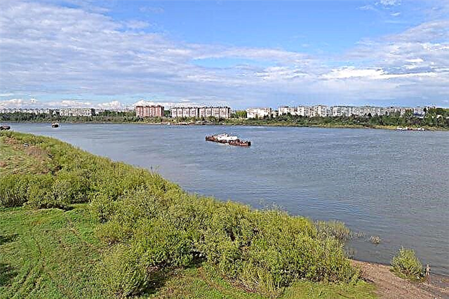
Tom
It flows through several regions - Tomsk and Kemerovo, as well as through the Republic of Khakassia. In the Tomsk region, on the banks of the river, there are several natural monuments - the Basandai forest park, geological formations in the Camp Garden of Tomsk, Vershininsky pine forest. Tom has clean, clear water, which is home to a large number of different types of fish.
The length of the river is 827 km, in the Tomsk region - 125 km.
Kiya
The nature of the river banks is varied. There are flat areas with meadows and places with dense taiga forest. There are also jagged rocks, reaching 20 meters in height, from which waterfalls flow into Kiyu. Kiya is a floating river, among the rocks it has a stormy current, and in meadow areas it is calm. It is difficult to get to the river by ordinary cars; it is better to use off-road vehicles. It flows through two regions - Tomsk and Kemerovo.
The total length of the river is 548 km.

Chizhapka
The source of the river is located in the lake Vasyugansikh bogs. The river itself flows mainly through flat marshy terrain, there are areas with mixed and coniferous forest. In the middle reaches of the Chizhapka, there are several gas and oil fields. For their development, roads, technological stations and a rotational camp have been built. In addition to this village, there are no more settlements on the river.
The length of the river is 511 km.

Kyunga
A meandering river with high banks and several sections with a fast flow. The water in the river has a dark color almost along its entire length, because its source is in swamps. The banks of the river are poorly populated. Gyeonga village is home to about 100 people. Kyonga, at its confluence with the Chuzik River, forms the small Parabel River. There are many small lakes in the river basin. There are fish in Gyeong, but there are not very many of them.
The length of the river is 498 km.

Paidugina
There are no settlements on the river. Rare travelers will find on the shores only the ruins of abandoned villages and villages - Old Imber, Borki, Berezovka. There are no bridges across the Paidugin River, it is not navigable. The river takes its source in Lake Bolshoye Ozernoe with an area of 6.3 km². The width of the river varies and reaches from 10 to 150 meters. It flows into the Ket River. Paidugin is inhabited by nelma, pike, ide and perch.
The length of the river is 458 km.

Chichkayul
It flows through the Chulym Valley and is a tributary of the Chulym River. The former name of the river is Chichka-Yul. The river is 5-15 meters wide on average. Almost 200 km of the river are navigable. The ichthyofauna of Chichkayul is represented by perch, ruff, crucian carp, pike, pike perch. The river is rarely visited by tourists due to the lack of accessible approaches to it. This allows the nature around to remain wild and protected.
The length of the river is 450 km.

Cheat
For the most part, the river flows in the Tomsk region, but its upper reaches are located in the Krasnoyarsk Territory. The river mainly flows among small hills overgrown with dark coniferous trees. In the floodplain of the river there are lakes of different sizes, meadow places. The cheek is used for timber rafting. Sometimes the forest forms blockages of several hundred meters. Cheti is inhabited by minnow, grayling, soroga, catfish.
The total length of the river is 432 km.

X
It flows through two regions - Tomsk and Novosibirsk. On the border between them is the source of the river, in the upper reaches the river flows along the border of the regions. There are several small villages and settlements on the banks of the Iksa. One of the unusual sights is the abandoned hydroelectric power station. Only the remains of a turbine hall, a sluice and a dam have survived from this industrial monument of the Tomsk region.
The total length of the river is 430 km.

Fox
In the swamps of the Ob-Yenisei section, the river originates and flows into the Ket River near the village of Bely Yar. It flows through the boggy taiga. A little more than 300 people live in the village of the same name on its banks. Several dozen rivers will flow into the Fox. The longest tributary is the Raiga River with a length of 158 km. Getting to Lisitsa is not easy, so travelers and fishermen rarely come here.
The length of the river is 417 km.

Uluyul
Tributary of the Chulym River. Several crossings have been built across Uluyul, including a railway bridge. Several archaeological objects have been discovered on the river banks - barrows, fortified settlements and burial grounds. The ichthyofauna of the river is diverse - burbot, pike, perch. The coastal landscape is represented by woodlands with ravines; there are ponds and lakes in the river basin. The longest tributary is the Chebak River.
The length of the river is 411 km.

Chuzik
Tributary of the Parabel River. The winding river originates in the Vasyugan swamps. This shallow and narrow river flows in a wooded taiga area. There is fish in the Chuzik River, it is possible to swim along it by boat. On its banks are the dwellings of the Old Believers who are engaged in cattle breeding, agriculture and fishing. There are also several small villages and villages, some of them are abandoned.
The length of the river is 382 km.
Shegarka
The tributary of the Ob, the source of the river is in the Vasyugan plain. The river bed is sandy. The nature of the steep banks is beautiful - cedars, willows and pines grow on them, there are a lot of reeds and water lilies in the water. All along the river is suitable for rafting, the lower 200 km are navigable. Among professional raftsmen, Shegarka rafting is rated according to the first category of complexity. It flows through the Novosibirsk and Tomsk regions.
The total length of the river is 382 km.

Yaya
It is a tributary of the Chulym. The winding river bed in the upper reaches flows through the mountains and hills. In the lower reaches, the river acquires a flat character. The banks of the river are overgrown with birch and coniferous forests. There are sandy areas suitable for swimming and relaxing by the water. Yaya is popular for rafting, but more interesting for fishermen. It is inhabited by gudgeon, perch, pike, dace, ide, roach. It flows through the Tomsk and Kemerovo regions.
The total length of the river is 380 km.

Yagylyakh
The upper reaches of the river and its source are located in the Omsk region, but mainly the Yagylyakh flows in the Tomsk region. It flows into the Vasyugan River near the small village of Ognev-Yar. There are oil fields in Yagyl. The 2011 oil spill severely damaged the river's ecology. The restoration of ecology is an important matter, because rare species of mosses and vascular plants grow in the Yagyl'yakh valley.
The total length of the river is 368 km.

Bakchar
It merges with the Parbig River and forms the Tea River. The meandering river bed is 10 meters wide on average. The calm course of the Bakchar river is perfect for rafting. The river is inhabited by common fish species - pike, perch, crucian carp. The longest tributary of the Bakchar River is the Galka River. Its length is 145 km. It is on Galka that the village of Bakchar is located, with a population of more than 5000 people.
The length of the river is 348 km.

Nyurolka
The source of the river is formed by the confluence of the Bolshaya and Malaya Nyurolka rivers in the Vershinonyurolsky bog. The village of Myldzhino, located on the banks of the river, is home to a little less than 400 people. The banks of the river are covered with stunted trees. Nyurolka is a floatable river, has a flat character, but is rarely used by travelers and tourists. Several streams and small rivers flow into Nyurolka along its entire length.
The length of the river is 339 km.

Kiev Yogan
The source of the river is located between the tracts of the Laryogansky Islands and the High Continent. It flows into the channel of the Kiev Ob River. A winding river flows through a marshy area. The river is fed by snow and rain waters. In the lower reaches of the Kiev Yogan, it forms several lakes. It has many tributaries. There are no settlements on the banks of the Kievsky Yegan River. This allows you to keep the nature of its shores virgin and beautiful.
The length of the river is 339 km.

Yoltyreva
In the upper reaches it is known as Zhigalova. The river takes its source in the Swan Lake. The mouth of the river is 60 meters below sea level on the Ket River. Yoltyreva flows through the swamps of the West Siberian Valley. The river is under ice from October to May. There is a flood period until July. The river is fed by snow and rainwater, and several dozen streams also flow into it.
The length of the river is 332 km.
Orlovka
Among the small Selkup people living in Western Siberia, the river is known as Lymby Ky. Translated from Selkup, the name means "Eagle River". Orlovka is a tributary of the Ket River. On the banks of the Orlovka there are two small villages - Central and Druzhny. The large tributaries of the river are the Wolverine and Churbiga rivers. The river feeds mainly on snow waters.
The length of the river is 327 km.

Parbig
The source of the river, as well as its entire course, are located on the Vasyugan plain. Parbig merges with the Bakchar River and forms the Chaya River. The river goes under the ice at the end of October, the river opens up at the beginning of May or the end of April. The high water ends in June. The lower course of the river is navigable. On the river are the village of Kedrovka and two villages - Parbig and Ust-Bakchar. Several tributaries of the Parbig are over 100 km long.
The length of the river is 320 km.